Editions list close
  • October 2026

    October 12, 2026

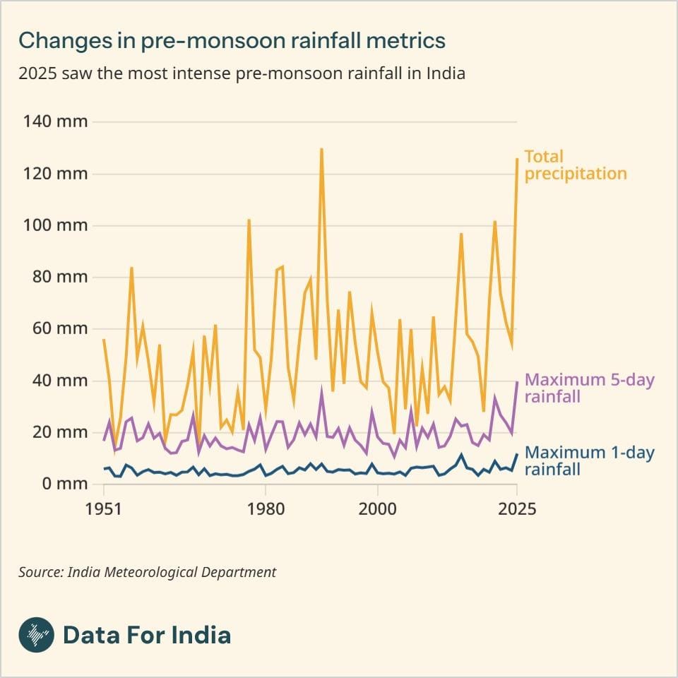
    2025 saw the most intense pre-monsoon rainfall in India
    The Data Byte that went out earlier this morning was one that we had published last month. We apologise for the error; this is this week's Data Byte.

    While the majority of India's rain falls during its south-west monsoon, the pre-monsoon season (March-May) also accounts for a share of the precipitation. The 2025 pre-monsoon season in India stands out as one of the most extreme on record.

    Three key rainfall indicators-total precipitation, maximum one-day rainfall, and maximum five-day rainfall-capture the severity of short-duration rainfall events. Total precipitation is the cumulative rainfall received during the pre-monsoon season. Maximum one-day rainfall represents the highest rainfall recorded in a single day during the season. Maximum five-day rainfall measures the highest rainfall accumulated over any consecutive five-day period.

    In 2025, the maximum one-day and maximum five-day rainfall both recorded their highest values since 1951. Together with the near-record total seasonal precipitation, these indicators suggest that pre-monsoon rainfall is becoming both heavier and more concentrated during heavy spells. All three indicators show an upward trajectory over the past seven decades, with the sharpest increases occurring after 2015.

    Historically, the pre-monsoon was relatively drier, averaging just 10-15 rainy days and 20-50 mm of cumulative rain at the national level. Recently, however, both rainfall frequency and totals have increased, with 2025 recording seasonal precipitation of 126 mm - the second-highest value since 1951.

    The increasing concentration of rainfall into one-day and multi-day events has important implications for disaster risk, agriculture and urban infrastructure.

    Read about the seasons in India that have got wetter and drier.

    Climate
    Copy citation
    1. 2025 saw the most intense pre-monsoon rainfall in India by Juhi Chatterjee, Data For India (October 2026): https://www.dataforindia.com/data-bytes/2025-saw-the-most-intense-pre-monsoon-rainfall-in-india/

  • September 2026

    September 7, 2026

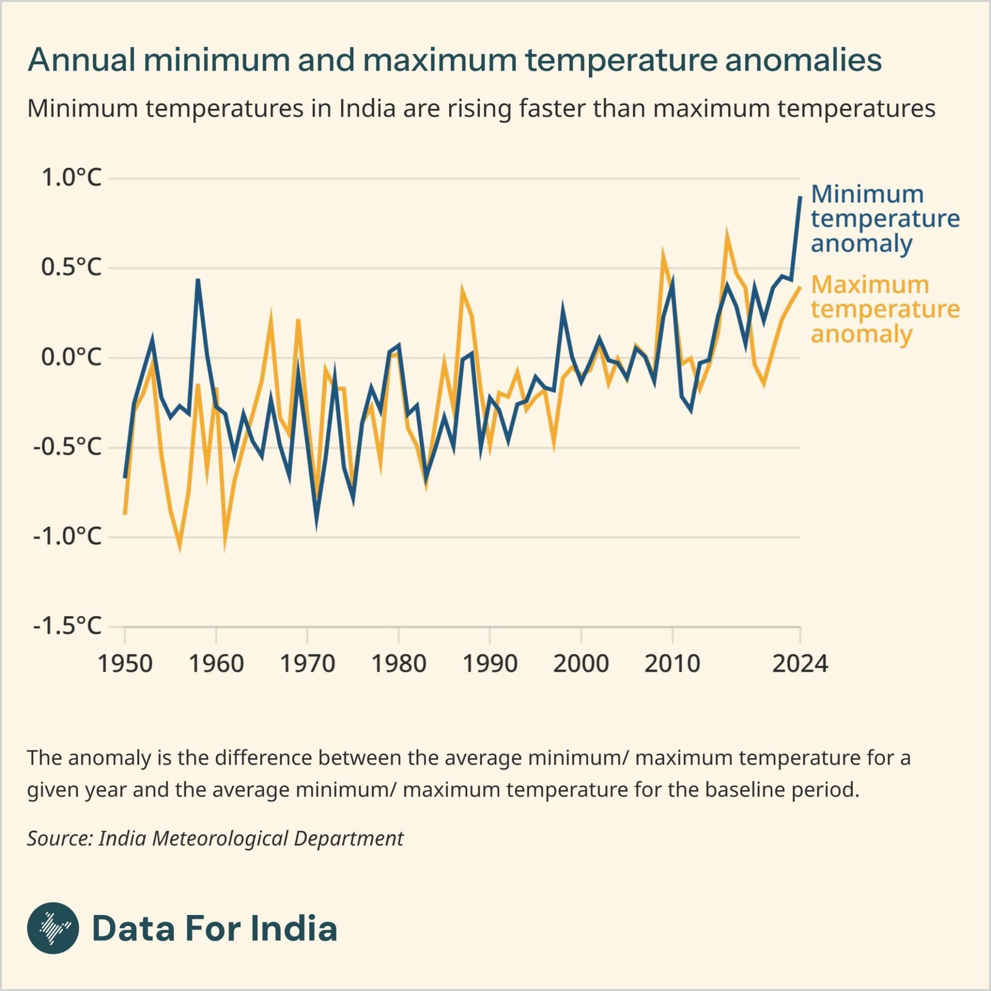
    Minimum temperatures in India are rising faster than maximum temperatures

    Warming in India is not occurring uniformly. While both daytime and night-time temperatures have risen over the past seven decades, minimum temperatures have increased faster than maximum temperatures, indicating that nights are warming more rapidly than days.

    An anomaly is the departure of a given year's temperature from the long-term average over a reference period. The current baseline in use in India is the average of the 1990-2020 period.

    During the 1950s up to the 1980s, both maximum and minimum temperatures fluctuated around the baseline, with some years warmer and some cooler.

    In recent years, however, the data shows not just sustained warming, but a sharp acceleration, particularly in minimum temperatures.

    Since 2020, the pace has increased markedly. The minimum anomaly rose from +0.43°C in 2023 to approximately +0.90°C in 2024 - the highest recorded value in the entire series. The maximum anomaly reached +0.40°C over the same period, showing the faster pace of increase in the minimum temperature anomaly.

    Together, the persistence of positive anomalies and the faster increase in minimum temperatures point to a warming climate in which heat is becoming both more intense during the day and more sustained through the night. This asymmetry limits overnight recovery, raising health risks, affecting agriculture, increasing energy demand and intensifying heat stress on vulnerable populations.

    Read more about the pace of warming in India.


    Climate
    Copy citation
    1. Minimum temperatures in India are rising faster than maximum temperatures by Juhi Chatterjee, Data For India (September 2026): https://www.dataforindia.com/data-bytes/minimum-temperatures-in-india-are-rising-faster-than-maximum-temperatures/

  • July 2026

    July 13, 2026

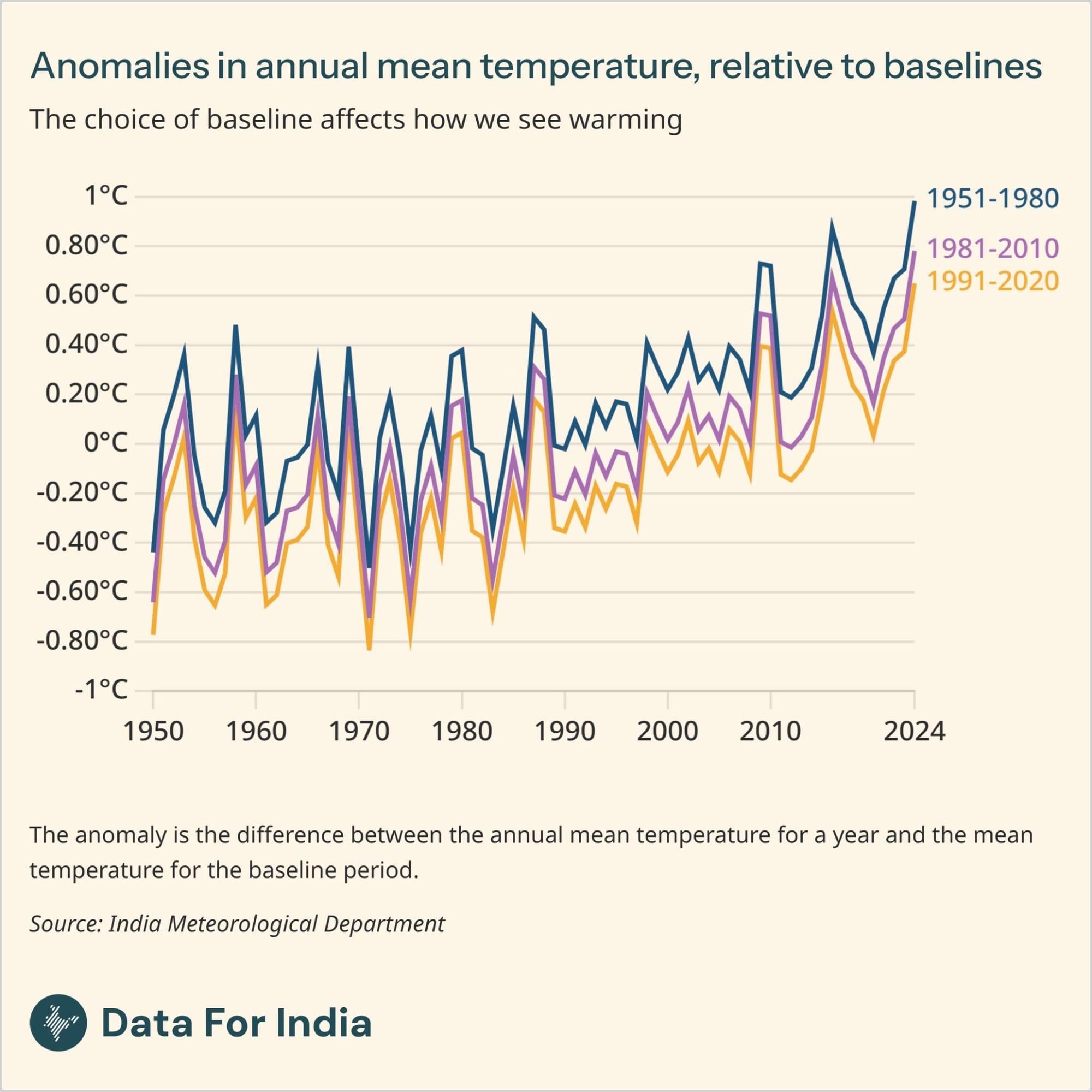
    The choice of baseline affects how we see warming

    One of the best measures to understand warming is through temperature anomalies. A temperature anomaly is the departure of the temperature for a particular year from a baseline. Positive anomalies indicate warmer than average conditions, while negative anomalies indicate cooler conditions when compared to the baseline.

    This baseline or reference period is also referred to as the Long Period Average (LPA), and represents the average climatic conditions over a multi-decadal period of typically 30 years when measuring changes in temperature.

    Temperatures today are typically measured against a reference period of 1991-2020, which is the baseline now in use by the India Meteorological Department, the official source of climatological data in India. However, looking at a range of baselines can provide important insights.

    Using older baselines, such as 1951-1980, produces larger positive anomalies for present day temperatures with the anomaly estimated to be 0.98°C in 2024. More recent baselines, such as 1991-2020 produce smaller anomaly values for the same year with anomalies reducing to around 0.65°C. An intermediate baseline of 1981-2010 shows warming of a magnitude in between the two at approximately 0.78°C for 2024.

    Updating baselines is important for climate monitoring because newer reference periods represent the current climatic conditions experienced by populations better. At the same time, older baselines highlight the cumulative scale of long-term warming. All baselines, however, show a warming trend.

    Read more about what is driving rising temperatures in India.


    Climate
    Copy citation
    1. The choice of baseline affects how we see warming by Juhi Chatterjee, Data For India (July 2026): https://www.dataforindia.com/data-bytes/the-choice-of-baseline-affects-how-we-see-warming/